THE FIRST LANGEVIN BRIDGE AND ITS SUBSEQUENT REPLACEMENT
Calgary’s early frontier day’s bridge history, to say the least, is scanty.
What historians do know is the location of the first Langevin Bridge built in 1888, was an ancient primary river crossing forded on the Old North Trail, an important First Nations transportation corridor.
In 1877, the Northwest Mounted Police force report from Fort Calgary stated “the Bow River is broad and rapid and crossings are made by temporary rafts and wagons with the wheels removed”, and their 1877 police account books show a sum of $50 “paid to H. Paquette for building a ferry boat for the Bow River.” This, possibly one of the earliest ferries on the river in the area. In 1882, Fogg’s Ferry was installed on the Bow in close proximity to McTavish Street, just about where today’s Centre Street Bridge stands, four blocks west of the present site of the Langevin bridge. In 1883, after the Canadian Pacific Railway arrived, and with scores more travellers and supplies for the north to be transported across the river, a new ferry was built, capable of crossing six loaded wagons on one trip. This ferry, the Calgary Bow River ferry continued to operate until the first Langevin bridge was built in 1888. (Even after the advent of ferries, river crossings could be unpleasant, hazardous and the fees charged for the ferry’s use high.)
In its Friday, November 2, 2025 issue, the Herald, (The Calgary Herald, Mining and Ranche Advocate and General Advertiser – to give its full name), disclosed Edmonton businessmen were offloading freight destined for the north at the C.P.R.’s Siding 19 (at Sheppard) east of the Bow River, in order to avoid the use of the costly Calgary Bow River ferry, and have their freighting done as cheaply as possible. The Herald called on Calgarians to take steps to protect the freighting trade, with an appropriation of public funds for the “construction of a Bow River bridge across this highway of commerce to the north…”
During the summer of 1885, an engineer from the Federal Department of Public Works, Walter F. Gouin arrived to inspect possible sites.
The police barracks, the current location of the ferry, or opposite the section line by the McHugh property of the Dominion Government on Section 16, were the sites he identified. Following his inspections, $12,000 was a final cost determined and included in the Federal Public Works budget for a bridge across the Bow River in the vicinity of Calgary, money well expended.
In July 1886, recently elected Calgary members on the Council of the Northwest Territories, Hugh S. Cayley, Editor of the Herald and John D. Lauder, MD were requested by Edgar Dewdney, Lieutenant Governor of the Northwest Territories to arrange for Edward J. McCoskrie, the first City Engineer (1885-1886) of Calgary at the time, to prepare the plans.
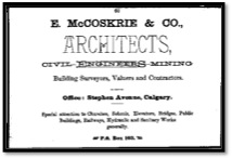
AD for E. McCoskrie & Co. Source: BURNS & ELLIOTT, CALGARY, HER INDUSTRIES and RESOURCES, MARCH, 1885.
Mr. McCoskrie who had upwards of thirty years’ experience in his profession, came to Calgary in February 1884. Apparently he had a rather tainted reputation as a habitually drunkard, having failed to properly pay special attention to and supervise his engineering plan and construction blunders, re: the Mission bridge across the Elbow, and to construct water tight tanks for Calgary’s first fire suppression system. Nevertheless in August of 1886, Messrs McCoskrie, McMillan and Kempt made a complete reconnaissance of the river and selected four potential spots between the ferry site, and the current day location of the Louise Bridge.
The location of the bridge was a matter of considerable debate. In February 1887, the Calgary Town Council endorsed the ferry site that had been the central crossing for years of all trades and freighters to and from the Great Northern District. It also led directly into the centre of the business portion of town.
In May 1887, a contract was signed with Ottawa contractors Kennedy and Heney for the construction of a three span Howe wood-truss bridge at the ferry site.
Files of the Herald indicate there was bridge-building controversy from the outset, for in September 1887, much was written about the Bow River’s first structure when plans called for it to be but 14 feet wide. There were loud complaints this would not allow teams or carts and wagons to pass. Fortunately construction had just started and the bridge was widened to 17 ½ feet.
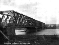
File number: NA-4081-10
Title: The first Langevin bridge over Bow River. Date: Unknown.
The government bridge opened for use in mid-February 1888, without any ceremony. At times it was called the Dewdney Bridge after Dewdney Street – now 4th Street S.E., or as the Bow River Bridge until March 28, 1888, when the community christened it the Langevin Bridge after Sir Hector Louis Langevin, (Photo: Sir Hector Langevin. Library and Archives Canada/PA-026714) the federal Minister of Public Works, as a result of his foresight in 1885 in petitioning the Northwest Territories Government for funds to build a bridge across the Bow River, and also in the hopes that Langevin would take a personal interest in its welfare and arrange to have it painted.
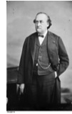
Photo: Sir Hector Langevin. Library and Archives Canada/PA-026714
By 1892 the planking was so worn that horses and wagons were breaking through and frequent petitions were necessary to keep the bridge in repair.
In 1907 the separate village of Riverside (dubbed Germantown) at the north-east end of the bridge, petitioned for annexation and the Provincial Government was approached to replace the Langevin bridge across the Bow River with a new steel bridge, which was built in 1910.
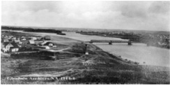
File number: NA-1114-1
View of Germantown (Riverside) looking east towards Calgary, the Langevin Bridge connecting the village to the rest of Calgary, ca. 1900.
Its design was developed by American Civil Engineer Charles H. Parker as a modified version of a Pratt Truss bridge, made of riveted steel. The style is distinguished by a framework of structural elements in a triangular arrangement connected at the top, looking like a camel’s back in profile. The steel for the new bridge to replace the old 1888 Langevin bridge, was manufactured in Eastern Canada by the architect, Canadian Bridge Company, shipped west by rail and assembled on site with rivets.
![File number: NA-1785-1 Title: Langevin Bridge and Bow River. Date: [ca. 1912]](../wp-content/uploads/2014/10/5.jpg)
File number: NA-1785-1
Title: Langevin Bridge and Bow River. Date: [ca. 1912]
Erected in 1910 the bridge is a 383 foot or 116.58 –meter- long and 29 feet or 14.02- meter-wide, two-span on a concrete substructure made up of one pier and two abutments. It has 5 foot or 1.5 meter steel sidewalks on either side of the superstructure with a lattice balustrade, (i.e. railings with supporting supports bordering the bridge).
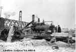
Image No. NA-4081-8
Title: Construction work on bridge. Date: Feb. 1910.
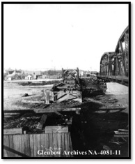
Title: Old and new Langevin bridges over Bow River. Date: February 1911
In its March 2, 2026 issue the Albertan reported, “the old (1888) Langevin bridge will soon be assisting to heat Calgary houses, for the woodwork has been bought by a wood firm, who started pulling it down yesterday.”
“The rock support at the side of the river will be used as protection work for the new bridge.”
This article also posed the following question to its readers, “Should the name of the new bridge across the Bow be “Langevin” after the old one, or should it be changed to “Riverside?”
The premier of Alberta, Hon. Arthur L. Sifton, who was passing through Calgary, thought that the old name would pass muster. However, he could say nothing definite, as the matter had not been considered at all.
City Engineer (1908-1912) of Calgary, James T. Child personally thought it should be named so as to show people immediately in what district it was located. Riverside, for instance, indicated at once to what part of the city it led, thus arousing a good deal of general discussion. (However, it remained named “Langevin”.)
In 1911, the city raised the approach road levels at both ends of the bridge to permit easy passage of the Municipal Streetcar Railway system. The system was extended further north to serve as a regular route to all of Crescent Heights & the new subdivision of Tuxedo Park further up the Calgary and Edmonton Trail (now Edmonton Trail). In the 1950’s the rails, (i.e. streetcar tracks) laid on the streets were removed or sometimes simply paved over and replaced with a modern fleet of rubber-tired overhead electrified wire powered trolley buses.
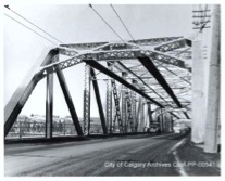
Source: http://www.albertaonrecord.ca/is-ccg-2620 Date: 1960’s
The Langevin Bridge remained part of the main highway route north from Calgary to Edmonton (via Highway No. 2), until the construction of the Deerfoot Trail in the late 1960’s. The approach road levels were changed again in 1972 with the construction of the 4th Avenue Fly-Over. The old bridge (i.e. Langevin) is used as two-lanes southbound access connecting Bridgeland to downtown Calgary. The 4th Avenue Fly-Over connects Memorial Drive to downtown Calgary and the 5th Avenue Fly-Over connects downtown Calgary northbound to Memorial Drive, Crescent Heights and Bridgeland.
Launched on Wednesday, December 23rd, 2009 – the Langevin Bridge was lit with more than 5,600 LEDs that are oriented to highlight every beam and truss of the bridge structure. Colours and sequences can be computer programmed with the seasons, and in honour of holidays and events. The lighting consumes roughly per year, the consumption of three Alberta households and responds to a public safety concern that the bridge wasn’t well lit.
The project cost about $370,000.
The Calgary Heritage Authority recently completed a historical survey of Calgary’s bridges. A press release from the Mayor’s Office under date of January 27, 2026 made known the Langevin Bridge was one of four historic bridge sites to be recognized/honoured with a Calgary Heritage Authority plaque. The plaque when placed will help build awareness and information about the value and importance of the bridge which has connected generations of Calgarians.
At the current age of 104 years, the Langevin Bridge is a significant historical landmark still in use in the oldest, newest, community of East Village. It’s a “gateway” feature to both Bridgeland-Riverside and downtown Calgary.
S N I P P E T
 SIR HECTOR LOUIS LANGEVIN – politician; father of Confederation: Born, Friday, Aug. 25, 1826, in Quebec City; died there, Wednesday, July 11, 1906. Called to the provincial bar, 1850 (Q.C., 1864); married Marie Justine Tetu in 1854 (died 1882), they had nine children. Became recognized leader of the French-Canadian Conservatives. Served as minister of public works, 1867-73; resumed the portfolio, 1879-91; though personally exonerated, resigned in 1891 re: charges of corruption brought against his department.
Researched and complied by: M.P. (Pat) Hooper
 Word processing by: Susan Hooper
SOURCES CONSULTED:
 * LIMITED EDITION BOOK – HOUSED IN CITY CLERK’S OFFICE – The Bridges of Calgary 1882-1977 edited by city commissioner – Robert Welin
 * FERRIES AND FERRYMEN IN ALBERTA – by ELIZABETH HAESTIE, 1986 and CANADIANA ENCYCLOPEDIA #6 GLENBOW LIBRARY AND ARCHIVES
 * CLIPPING FILES, CPL LOCAL HISTORY ROOM
 * THE CITY OF CALGARY – SEARCH OF THE INVENTORY OF EVALUATED HISTORIC RESOURCES
 * CHINOOK COUNTRY HISTORICAL SOCIETY – FALL 2013 NEWSLETTER – THE FIRST LANGEVIN BRIDGE, by JOHN GILPIN